
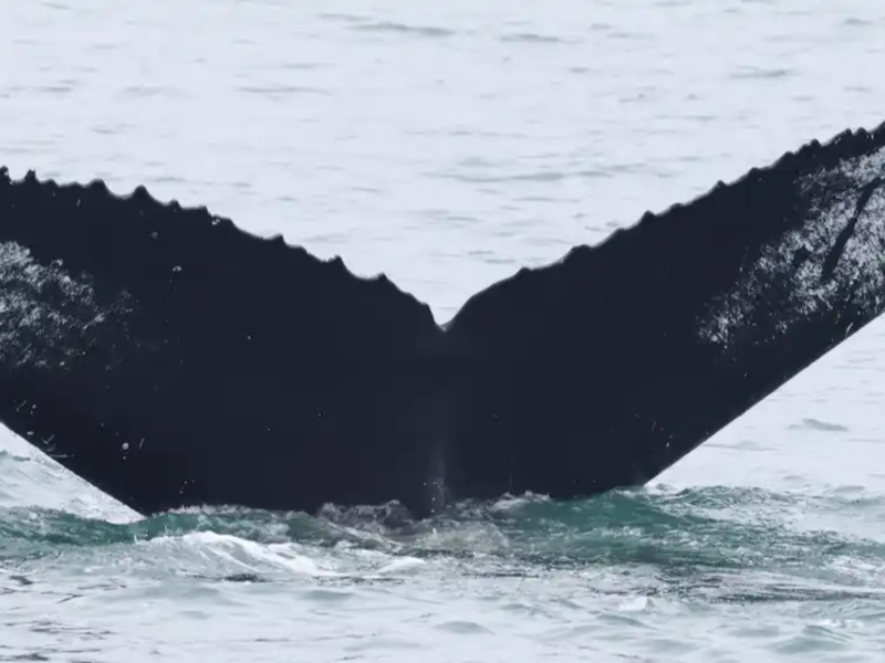
Happy Whale Humpback Happenings
June 22, 2026
A few interesting matches have come out of our Mid-Atlantic Humpback Whale Catalog efforts and partnership with Happy Whale!
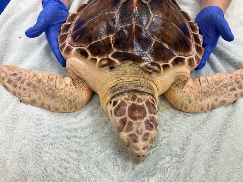
Kemp’s ridley / Loggerhead Hybrid Turtle Tagged at Jekyll Island
June 15, 2026
Researchers were surprised by an unusual turtle that stranded in Georgia-- a Kemp’s ridley / Loggerhead Hybrid Turtle, and were able to tag the animal for release.
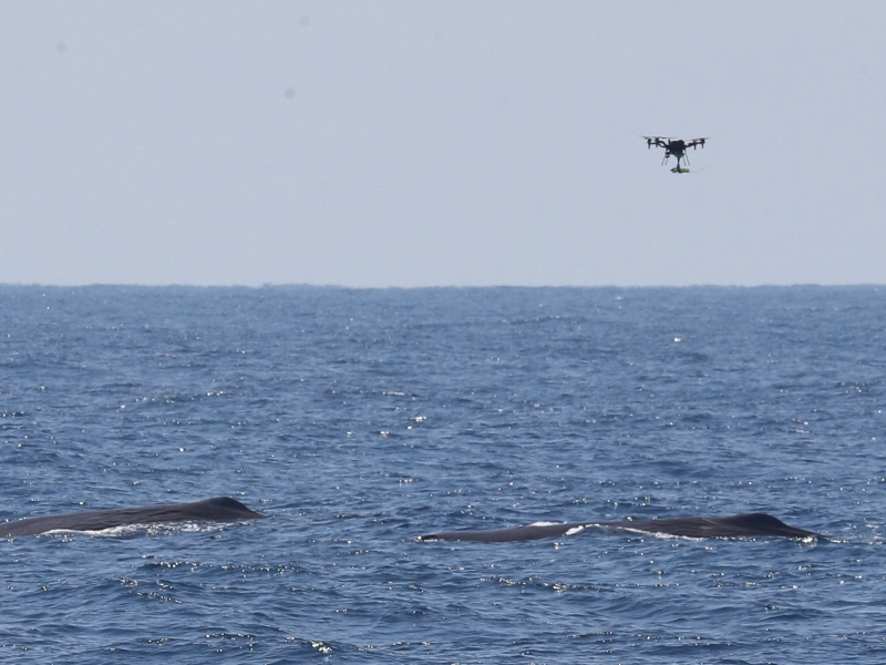
A Macrocephalus Mother's Day Tradition
May 27, 2026
HDR-lead team encountered a group of mainly female sperm whales with calves on Mother's Day for the 2nd year in a row, and successfully deployed a tag from a drone. We believe it's the first CATS tag deployed on a sperm whale via drone.
Current
Pilot Project to Assess Feasibility of Multi-Sensor Tagging of Rough-Toothed Dolphins at the Pacific Missile Range Facility (PMRF)
Project Objectives
Determine feasibility and efficacy of deploying high resolution multi-sensor tags on rough-toothed dolphins at PMRF and determine how collected data can be used to move toward a better understanding of the effects of Navy activities, ultimately leading to PCoD modelling.
Current
Visual Survey and Tagging of Hawaiian Odontocetes
Project Objectives
(1) define the spatial movement and habitat use patterns of species that are exposed to mid-frequency active (MFA) sonar (2) determine how these patterns influence exposure and potential responses
Complete
Passive Acoustic Monitoring in the Mariana Islands: Density Estimation of Beaked Whales along the West Coast of Guam
Project Objectives
Determine what species of marine mammals, specifically beaked whales, are present in the Marianas and examine their spatial and temporal patterns of acoustic behavior. Calculate acoustic abundance and density of beaked whales in surveyed area. Analyze sonar detections in area.
Complete
Hawaiian Monk Seal Tagging
Project Objectives
Investigate potential impacts of naval activities on Hawaiian monk seals
Current
Monitoring Cetaceans in Hood Canal
Project Objectives
This 12‑month integrated pilot project combines three complementary components: (A) shore‑based theodolite monitoring of harbor porpoises, (B) high‑bandwidth passive acoustic monitoring and soundscape characterization, and (C) suction‑cup multi‑sensor tag deployments on Bigg’s (transient) killer whales. Together, these data streams will quantify occurrence, movement, diving, and behavioral context for these two key species in relation to the local soundscape—including operational signals near the Dabob Bay Range Complex (DBRC) and the Bangor Trident Base. Results can provide an empirical foundation and inform the study design of future cetacean behavioral response studies (BRS) in Hood Canal.
Complete
Mariana Islands Sea Turtle and Cetacean Survey (MISTICS)
Project Objectives
Determine what species of marine mammals and sea turtles are present and estimate abundance.
Current
Marine Mammal Monitoring on Navy Ranges (M3R)
Project Objectives
Improve understanding of the long term trends in occurrence of marine mammals on the PMRF and SOAR ranges.
Complete
North Pacific Humpback Whale Tagging
Project Objectives
Determine the occurrence, movement patterns, and residency patterns of multiple humpback whale Distinct Population Segments within Pacific Ocean Navy Range Complexes
Complete
Blue and Fin Whale Satellite Tagging
Project Objectives
Determine the movement patterns, occurrence, and residence times of blue whales and fin whales within U.S. Navy training and testing areas as well as Biologically Important Areas along the U.S. West Coast
Current
Long Term Acoustic Monitoring of Marine Mammals Utilizing the Instrumented Range at Pacific Missile Range Facility (PMRF)
Project Objectives
Improve understanding of the long term trends in occurrence of marine mammals (e.g., minke, humpback, fin, Bryde's, Blainville's) on the PMRF range. Examine what, if any, acoustic and physical behavioral responses occur to Navy activities.
Complete
Acoustic and Visual Survey for Cetaceans in Behm Canal and Southern Clarence Strait, Alaska
Project Objectives
Conduct visual line-transect surveys and passive acoustic monitoring for cetaceans, and other marine mammals, to determine species occurrence, and to estimate density within Navy’s testing range. Acoustic monitoring devices will be deployed during the vessel based survey, and long-term passive acoustic hydrophones will be monitored for year-round detection of rare and/or cryptic cetacean species.
More details
Collapse details
Date Published:
Filesize:
- August 1, 2016
The ultimate goal of this study is to provide the United States (U.S.) Navy with the necessary data to help identify seasonal areas where cheloniid sea turtles are likely to occur in order to inform U.S. Navy environmental planning efforts. This project focuses on the three cheloniid sea turtle species commonly seen in Virginia.
- 4,712.58 KB
More details
Collapse details
Date Published:
Filesize:
- April 1, 2018
Five species of sea turtles occur in Chesapeake Bay and the coastal waters of Virginia with varying regularity. They include the loggerhead turtle (Caretta caretta), Kemp’s ridley turtle (Lepidochelys kempii), green turtle (Chelonia mydas), leatherback turtle (Dermochelys coriacea), and hawksbill turtle (Eretmochelys imbricata) (Musick and Limpus 1997). Loggerhead and Kemp’s ridley turtles are the most abundant and regularly occurring species, and green turtle numbers have increased over the past two decades in Virginia (Barco et al. 2015, Swingle et al. 2014, 2015, 2016).
- 1,259.42 KB
More details
Collapse details
Date Published:
Filesize:
- April 1, 2014
The goal of the project is to assess the occurrence, habitat use, and behavior of loggerhead, green, and Kemp's ridley turtles in the Hampton Roads region to better assess the impacts that U.S. Navy activities may have on these protected species.
- 1,337.08 KB
More details
Collapse details
Date Published:
Filesize:
- February 28, 2015
The ultimate goal of this study is to provide the US NAVY with the necessary data to help identify seasonal areas where cheloniid sea turtles are likely to occur in order to inform DOD sea turtle protection efforts. This project focuses on the three cheloniid sea turtle species commonly seen in Virginia, which are the loggerhead sea turtle, Kemp’s ridley sea turtle, and green sea turtle (Hager 2014).
- 6,910.62 KB
More details
Collapse details
Date Published:
Filesize:
- March 1, 2019
Kemp’s Ridley Tagging and Tracking in Chesapeake Bay and Costal Waters of Virginia: Final Report
- 285.40 KB
More details
Collapse details
Date Published:
Filesize:
- June 1, 2017
The goal of this report is to provide the United States (U.S.) Department of the Navy (Navy) with the necessary data to help identify seasonal areas where Kemp’s ridley and green turtles are likely to occur in order to inform Navy environmental planning efforts.
- 1,296.69 KB
Acoustic telemetry with sea turtles in Virginia.
GARSCON 2015 (Greater Atlantic Region Stranding Conference 2015). .
More details
Collapse details
Date Published:
Filesize:
- October 1, 2015
The Virginia Aquarium Foundation (VAQF) and the U.S. Navy have been working together since 2013 to determine the efficacy of using acoustic telemetry for investigating the fine scale movements of sea turtles in the vicinity of Navy facilities in southeastern Virginia. To date, we have deployed 56 acoustic tags (VEMCO V16, V13 and V9 69 kilohertz tags), 14 from Jul-Nov of 2013, 24 in 2014 and 18 May-Jul of 2015. The U.S. Navy maintains an array of 71 acoustic receivers (VEMCO VR2W) in southeastern Virginia and downloads and processes data every other month. There is a four to six month delay from the time of detection to VAQF receiving processed tag detection data. For this reason, we will discuss results for turtles tagged in 2013 and 2014. Of the 38 turtles tagged in 2013-14, five were wild caught (incidentally or directly captured) and 33 were stranded, rehabilitated and released. Of the stranded turtles, 14 were caught on recreational hook and line, 13 were cold-stunned and the rest were boat strikes (n=3), diseased (n=2) or entangled in other gear (n=1). In total we deployed tags on 18 loggerheads, 15 Kemp’s ridleys (one was released twice) and 4 green turtles. Of these 15 (83%) of the loggerheads were detected, 11 (73%) of the Kemp’s ridleys were detected and 3 (75%) of the greens were detected. Seven of the turtles stranded dead since release (3 wild and 4 stranded) and of these one was never detected. Seven turtles were released after mid-Oct south of the Navy receiver array and, of these, four were never detected. For loggerheads, Kemp’s and greens that were detected, mean number of detections were 220, 57, and 187, number of different days detected were 6, 3, and 10, and days post-release were 97, 21, and 53 respectively.
- 9,579.31 KB
More details
Collapse details
Date Published:
Filesize:
- November 1, 2019
This project is intended to provide baseline information on the species composition, density, distribution, and basic behavior of marine mammals and sea turtles present within the United States (U.S.) Navy’s Virginia Capes (VACAPES) Operating Area (OPAREA). This study is part of a larger, multi-institutional, marine mammal and sea turtle monitoring program of U.S. Navy range complexes along the U.S. Atlantic Coast and Gulf of Mexico supporting Atlantic Fleet Training and Testing (AFTT)
- 4,083.79 KB
More details
Collapse details
Date Published:
Filesize:
- February 10, 2022
Understanding the spatial distribution of a species is required to enact effective conservation. Complications to effective conservation can arise when the distributions of multiple target species are non-overlapping. Conservation efforts meant to protect one species may shift threats into the distribution of another species. Two species of marine turtle, loggerhead Caretta caretta and Kemp’s ridley Lepidochelys kempii, are common seasonally in Chesapeake Bay, a large estuary on the US east coast. Both species are protected under the US Endangered Species Act and face spatially complex threats in the region. We created habitat suitability models for these 2 species to inform conservation efforts in the region and explore the extent of overlap be - tween their distributions. Argos satellite tags were deployed on 24 Kemp’s ridley and 10 loggerhead turtles to record animal locations within the Bay. Boosted regression tree models were created for each species using presence-only animal locations, predicting suitable habitat within the Bay. Habitat for Kemp’s ridley turtles was predicted in shallow, coastal areas of the southern Bay as well as in brackish areas of rivers. Loggerhead turtle habitat was predicted to extend farther north than Kemp’s ridley habitat and was generally found in deeper areas of the middle Bay. There is some evidence that these 2 species are partitioning habitat. Any conservation measures adopted to conserve marine turtles in the Chesapeake Bay should consider the habitat of both species holistically to avoid shifting impacts from one species to another.
- 733.34 KB
More details
Collapse details
Date Published:
Filesize:
- August 1, 2020
To better understand the spatial distribution of habitat usage in the Bay by these species, the Navy funded home range analyses of both species based on extant satellite-tagging data for tags deployed from 2014 to 2018.
- 6,723.94 KB
More details
Collapse details
Date Published:
Filesize:
- February 1, 2025
The study team proposed deploying up to 50 Wildlife Computers satellite-linked telemetry tags per year for 3 years, split evenly between Kemp’s ridley and green sea turtles (or as encounters allow), at several sites along the East Coast ranging from Florida (FL) to Massachusetts (MA). In partnership with several rehabilitation and research groups, the study team aims to collect and record sea turtle behavioral data in multiple representative environments and times of year
- 4,815.55 KB
More details
Collapse details
Date Published:
Filesize:
- July 8, 2026
Building on Year 1 deployments, Year 2 moved the study toward providing robust, defensible availability bias models for green and Kemp’s ridley sea turtles on the East Coast. The current study results should be interpreted with caution, given the relatively small number of deployments to date, particularly for Kemp’s ridley turtles (n=10 deployments), which limits the available information both spatially and temporally. Collecting 18 months of data and expanding the analysis, compared to 6 months when the 2024 annual report (DiMatteo and Mansfield 2025) was written, reinforced several findings. Availability bias generally increased as the depth threshold at which animals were assumed to be able to be seen increased. This is to be expected as more of the water column is considered to be visible. The availability bias estimates from the 2-m depth histograms and dive behavior were similar.
- 13,940.82 KB
Habitat models and assessment of habitat partitioning for Kemp's ridley and loggerhead marine turtles foraging in Chesapeake Bay (USA).
Endangered Species Research. 2022.
47:91-107
More details
Collapse details
Date Published:
Publication:Ocean:Region:Species:Methods:
- February 10, 2022
Understanding the spatial distribution of a species is required to enact effective conservation. Complications to effective conservation can arise when the distributions of multiple target species are non-overlapping. Conservation efforts meant to protect one species may shift threats into the distribution of another species. Two species of marine turtle, loggerhead Caretta caretta and Kemp’s ridley Lepidochelys kempii, are common seasonally in Chesapeake Bay, a large estuary on the US east coast. Both species are protected under the US Endangered Species Act and face spatially complex threats in the region. We created habitat suitability models for these 2 species to inform conservation efforts in the region and explore the extent of overlap between their distributions. Argos satellite tags were deployed on 24 Kemp’s ridley and 10 loggerhead turtles to record animal locations within the Bay. Boosted regression tree models were created for each species using presence-only animal locations, predicting suitable habitat within the Bay. Habitat for Kemp’s ridley turtles was predicted in shallow, coastal areas of the southern Bay as well as in brackish areas of rivers. Loggerhead turtle habitat was predicted to extend farther north than Kemp’s ridley habitat and was generally found in deeper areas of the middle Bay. There is some evidence that these 2 species are partitioning habitat. Any conservation measures adopted to conserve marine turtles in the Chesapeake Bay should consider the habitat of both species holistically to avoid shifting impacts from one species to another.
Normalizing home ranges of immature Kemp's ridley turtles (Lepidochelys kempii) in an important estuarine foraging area to better assess their spatial distribution.
2021.
17(1): 57-71
More details
Collapse details
Date Published:
Ocean:Region:Species:Methods:
- January 1, 2021
Kemp's ridley turtles (Lepidochelys kempii) are critically endangered sea turtles that forage seasonally in Chesapeake Bay, a large estuary on the east coast of the United States. Most of the Kemp's ridley turtles foraging in the bay are immature. When tracking these animals, satellite transmitter retention times have been low compared with adult marine turtles of other species. The immature Kemp's ridleys' small size and rapid growth leads to shorter, more variable deployments, limiting the use of data. These limited data leave critical questions remaining about the animals' habitat usage that are difficult to answer without substantially more deployments. A novel sensitivity analysis using simulated deployments indicated that too few animals were tagged with satellite transmitters to identify all possible home-range areas in the Bay.
Sea turtle density surface models along the United States Atlantic coast.
Endangered Species Research. 2024.
53:227–245
More details
Collapse details
Date Published:
Publication:Ocean:Region:Species:Methods:
- February 29, 2024
Spatially explicit estimates of marine species distribution and abundance are required to quantify potential impacts from human activities such as military training and testing, fisheries interactions, and offshore energy development. There are 4 protected species of sea turtle (loggerhead, green, Kemp’s ridley, and leatherback) commonly found along the east coast of the USA, our study area, and which require impact assessments.
More details
Collapse details
Date Published:
Filesize:
- October 1, 2016
A combination of visual line-transect survey, photo-identification (photo-ID), and automated acoustic monitoring methods was used to gather important baseline information on the occurrence, distribution, and density of marine mammals near Naval Station Norfolk (NSN) and adjacent areas. The study area was designed to cover areas where United States Navy activity is substantial, including Chesapeake Bay waters near NSN and Joint Expeditionary Base Little Creek-Fort Story, as well as a Mine Exercise (MINEX) Area (W-50) in the Atlantic Ocean off the coast of Virginia Beach, Virginia
- 14,259.08 KB
Mid-Atlantic aerial surveys for marine mammals, sea turtles and other large marine vertebrates 1998-2012.
Mid-Atlantic Wildlife Surveys, Modeling, and Data Workshop (DOE Wind and Water Power Program Workshop) .
More details
Collapse details
Date Published:
- July 25, 2012
- 2,839.72 KB
More details
Collapse details
Date Published:
Filesize:
- March 22, 2022
The United States (US) Navy uses lookouts (LOs) to detect objects in the water in the vicinity of ships. One class of object that LOs are trained to detect is marine mammals ; this forms an important component of the Navy’s procedures for marine mammal mitigation during training activities . As well as dedications of marine mammals by these LOs, detections of marine mammals may also be made by other members of the ship’s crew such as officers on the bridge (“watchstanders”) or sonar technicians, although acoustic detections require visual confirmation. We refer to these personnel together as the “lookout team” (LT). The primary goal of this project was to determine how effective LTs are at detecting marin
- 4,078.84 KB
- California sea lion
- Green turtle
- Leatherback turtle
- Loggerhead turtle
- Kemp's Ridley turtle
- Blue whale
- Fin whale
- Humpback whale
- Minke whale
- Atlantic white-sided dolphin
- Common dolphin
- Harbor porpoise
- Killer whale
- Pantropical spotted dolphin
- Pilot whale
- Risso's dolphin
- Rough-toothed dolphin
- Short-finned pilot whale
- Sperm whale
- Spotted dolphin
- Striped dolphin
No related presentations or posters to display
